It’s never too early to start thinking about Christmas, especially when it comes to the weather. We’re still making our way through fall, but before long, Halloween decorations will come down, Christmas trees will go up and the annual question will start making the rounds: Will we have snow on the ground on Christmas morning?
There are a few numbers worth looking at before making any holiday-weather predictions. The National Weather Service has released historical data showing the odds of a white Christmas across the country, while AccuWeather has identified areas with a higher-than-average chance of seeing one this year. According to AccuWeather senior meteorologist Chad Merrill, much of the Mountain West is among the places with better prospects for a snowy holiday.
What Actually Counts as a White Christmas?
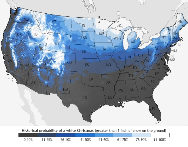
The National Weather Service’s Climate Prediction Center has a National White Christmas Map that provides a look at how likely different parts of the country are to have snow on the ground on Dec. 25. It’s based on climate averages from 1981 through 2010, giving us a 30-year look at typical Christmas weather rather than a prediction for any particular year.
There’s also a specific measurement behind the term. To qualify as a white Christmas on the map, a location needs to have at least 1 inch of snow on the ground Christmas morning. Snow falling during the day doesn’t necessarily count if it doesn’t leave that much accumulation behind.
The distinction matters because a few flakes in the air aren’t quite the same as waking up to a blanket of snow. The historical information comes from NOAA’s National Climatic Data Center and gives readers a way to compare the normal odds from one part of the country to another.
The National Weather Service also provides more localized information for parts of the Midwest, including Eastern Iowa, Northwest Illinois and extreme Northeast Missouri. Those figures use the same 1981-2010 climate averages.
The Mountain West Has Better Odds This Year
The historical map shows a clear difference between the northern and southern portions of the country. The Upper Midwest and Upper Northeast have traditionally had some of the strongest chances of having snow on the ground Christmas morning. Parts of the Northwest and the mountain regions also stand out.
Merrill’s outlook from AccuWeather adds another reason to keep an eye on the Mountain West. The forecast service identifies much of that region as having a higher probability than average of seeing a white Christmas this year. That’s an important aspect to notice: The historical map shows what has typically happened over several decades, while AccuWeather is highlighting areas with better-than-average prospects for this year’s holiday.
The southern states generally have a much tougher path to a snowy Christmas. Florida sits near the bottom of the historical map, with very little chance of having an inch of snow on the ground by Christmas morning. The contrast between the northern and southern parts of the country is pretty hard to miss.
Of course, none of this guarantees that a particular town will wake up to snow on Dec. 25. Christmas weather can change from year to year, and the historical map isn’t designed to predict conditions months in advance. Still, between the long-term climate data and AccuWeather’s outlook, there’s already a good reason for some parts of the country to start getting excited about the possibility of a white Christmas.